User Tools
Sidebar
wg7:gnss_vlbi:2016:328a:328a
This wiki is not maintained! Do not use this when setting up AuScope experiments!
Table of Contents
328a
GPS tracking test with WARK30M.
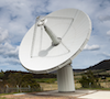
- Antennas: Wa
- Just a few GPS tracks to test tracking, etc., at Wa.
###################################################################################
# Schedule summary for session: 328a                                              #
###################################################################################
Nominal start:     2016-11-23 22:00:00
Nominal end:       2016-11-23 22:39:12
-----------------------------------------------------------------------------------
Scan#  Source name              Type  Start [UT]  End [UT]  Dur [s]  Sations
1      GPS BIIR-8  (PRN 16)     s     22:00:00    22:04:57  297      Wa
2      GPS BIIF-4  (PRN 27)     s     22:08:12    22:13:09  297      Wa
3      GPS BIIR-12 (PRN 23)     s     22:16:54    22:21:51  297      Wa
4      GPS BIIF-7  (PRN 09)     s     22:27:22    22:32:19  297      Wa
5      GPS BIIRM-6 (PRN 07)     s     22:34:15    22:39:12  297      Wa
-----------------------------------------------------------------------------------
Scheduling
- With VieVS Satellite scheduling tool, by A. Hellerschmied
- GPS scans manually scheduled
- 5 GPS sat.
- 1 scans per sat.
- 297 sec scans, if possible (~ 5 min)
- 297 sec = multiple of repos. int.
- Stepwise tracking with 9 sec repos. int.
- Schedule summary: 328a_sum.txt
- Sky plot: Wa
- Elevation/visibility plot: 2016-11-23_220000_elev.pdf
- VEX file: 328awa.vex.txt
Observation
- Observers: Tim Natusch
- Comments:
- Circular pol. at Wa
- From Tim:
- Schedule ran successfully
- Spread sheet of the results of monitoring signal power during the observation: 328awa.xlsx. Some things are obvious:
- We clearly saw all 5 satellites, although with significant variability in signal strength.
- We can clearly see the effects of the step tracking approach.
- I also monitored the DBBC IF attenuation during the run and at first glance it appears that the AGC loop had sufficient head room to maintain control (for my record keeping this was with 12 dB additional attenuation at the DBBC inputs).
- The slewing gap between recording seemed to be correct, I observed the antenna reach tracking position on all slews just before “record on” was commanded.
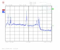
- Screen shot of the spectrum during tracking of the 2nd satellite “39166”:

Tracking
- Stepwise tracking
- 9 sec repos. int.
- VEX files with tracking points in topo. RaDec (calculated with TLE data)
Correlation
Available files
Files are available on the VieVS server (sorts@vievs.hg.tuwien.ac.at) at /home/sorts/GNSS_UTAS/2016/328a/
/home/www/auscope/opswiki/data/pages/wg7/gnss_vlbi/2016/328a/328a.txt · Last modified: 2016/11/30 07:13 by Andreas Hellerschmied